Arunachal Pradesh Space Application Center
Department of Science & Technology
Government of Arunachal Pradesh

Department of Science & Technology
Government of Arunachal Pradesh
UAV-Based Survey - Advanced Drone & GNSS Techniques for Transmission Corridor Mapping
Before a Power Transmission line is constructed, a design survey to map the transmission corridor is necessary. This project employs both GNSS and Drone techniques. Unmanned Aerial Vehicles (UAVs) are capable of providing meter-level accuracy in engineering surveys, making them ideal for terrain mapping in challenging environments.
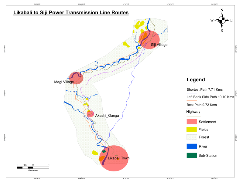
Transmission lines form the backbone in power networks, being the installations that transmit power over long distances. GIS plays a noteworthy role in route alignment optimization, enabling engineers to identify the most efficient paths while minimizing environmental and structural challenges.
This study focuses on exploring the significance and impact of employing drones for surveying purposes in the terrain of Arunachal Pradesh. Using drones equipped with advanced imaging and data-capturing technologies will transform surveying methodologies, enabling precise and comprehensive data collection across diverse terrains and environments.
High-resolution aerial imagery capture using UAV technology
Precise ground control point establishment using GNSS
Digital terrain model and contour map creation
ArcGIS Pro network analyst tool for optimal path selection
Along the east side of the national highways crossing Magi village. This route offers optimal terrain conditions with minimal elevation changes.
Shortest distance but significant elevation change. Most of the area falls under dense forest cover.
Moderate elevation change but located on the other side of the river with dense forest coverage.
Unmanned Aerial Vehicle for aerial survey and imagery capture
Global Navigation Satellite System for precise positioning
Advanced GIS software for spatial analysis and mapping
ArcGIS tool for optimal route path calculation
Digital Elevation/Terrain Models for terrain analysis
3D mapping from aerial photographs
Rapid data collection over large areas in minimal time
Meter-level precision for engineering survey requirements
Reduced risk for surveyors in difficult terrains
Lower operational costs compared to traditional methods
Access to remote and challenging terrain areas
Comprehensive datasets including imagery and point clouds
High voltage transmission line corridor planning
Highway and road route optimization
Rail corridor survey and planning
Oil, gas, and water pipeline alignment
Department of Power, Govt. of Arunachal Pradesh
Power Grid Corporation of India Limited
Arunachal Pradesh Space Application Centre
State infrastructure development bodies
Explore our advanced UAV and GIS-based infrastructure planning solutions.