Arunachal Pradesh Space Application Center
Department of Science & Technology
Government of Arunachal Pradesh
Department of Science & Technology
Government of Arunachal Pradesh
NWIA - Satellite-based Wetland Mapping at 1:25,000 Scale
National Wetland Inventory and Assessment (NWIA) project under the Satellite-based River Basin Hydrological Technique and Applications (SARITA) programme is taken up in collaboration with the Space Application Centre, ISRO, DoS, GoI under the aegis of Ministry of Environment, Forests and Climate Change, GoI.
The primary objective of NWIA is to create a comprehensive inventory of wetlands across India using advanced satellite remote sensing technology, enabling better conservation and management of these vital ecosystems for biodiversity and water resources.
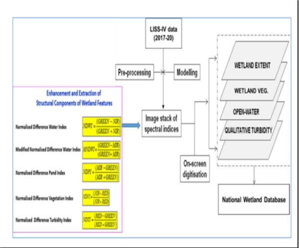
Under the project, various wetland classes are mapped using IRS LISS-IV data on 1:25K scale. The mapping involves visual interpretation combined with digital image processing techniques to accurately delineate wetland boundaries and classify them into various categories.
Natural freshwater bodies
Crescent-shaped water bodies
Pro/Supra-glacial lakes
Alpine and sub-alpine lakes
Aquaculture areas
Man-made water storage
Traditional water bodies
Saturated land areas
Space Application Centre, Indian Space Research Organisation
Department of Space, Government of India
Ministry of Environment, Forests and Climate Change, GoI
IRS LISS-IV satellite imagery for accurate mapping
Classification of 8+ wetland categories
1:25,000 scale for detailed analysis
Field validation for accuracy assessment
Comprehensive spatial database creation
Multi-temporal change detection capability
Natural filtration systems that clean water
Act as natural sponges during heavy rains
Habitat for diverse flora and fauna
Important carbon sinks for climate regulation
Replenish underground water sources
Support fishing and agriculture communities
Explore our range of RS & GIS programmes for environmental monitoring and conservation.