APSAC Logo

Arunachal Pradesh Space Application Center

Department of Science & Technology

Government of Arunachal Pradesh

Azadi Ka Amrit Mahotsav Government Logo
Space Technology Initiative

Plan of Action Using Space Technology for the Year 2021-24

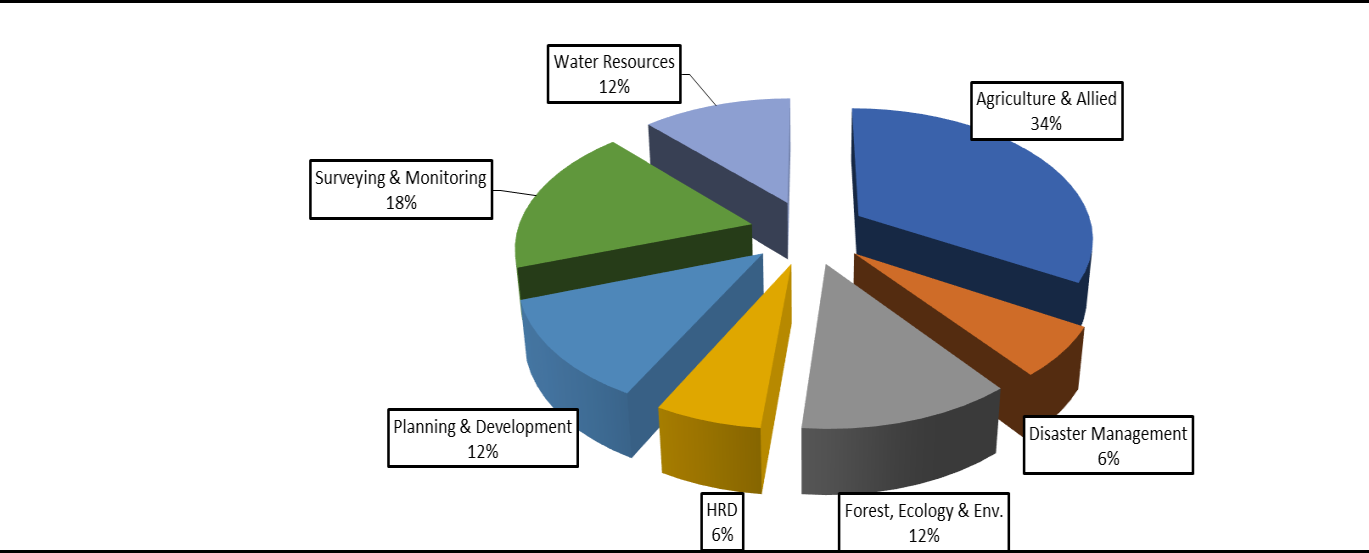
38 Projects - Approved under Hon'ble Union Home Minister's Chairmanship

Official Approval

On 24th July, 2021, 38 projects were approved in the meeting under the chairmanship of Hon'ble Union Home Minister at Shillong in presence of Hon'ble Chief Minister, Arunachal Pradesh and Ld. Chief Secretary, Govt of Arunachal Pradesh.

38 Total Projects
12 Regional Projects
26 State Specific Projects
6 Key Sectors

Key Sectors Covered

Agriculture & Allied

Crop mapping, horticulture resources, land inventory

Disaster Management

Flood warning, landslide hazard, lightning nowcasting

Forest, Ecology & Environment

Bamboo mapping, forest fire, wildlife habitat

Planning & Development

Rural development, cadastral mapping, infrastructure

Survey & Monitoring

Route alignment, asset mapping, site suitability

Water Resources Management

Groundwater mapping, watershed prioritization

Visual Overview

Project Distribution Chart

12 Projects

Regional Projects Under Plan of Action

Sl No. Project Title Funding Source Tenure (Months) Executing Agency
1
Site suitability study of major agricultural crops in selected districts of Arunachal Pradesh
NEC 36 NESAC
2
Acreage estimation of selected agricultural and horticultural crops
NEC 36 NESAC
3
Horticulture resource mapping in Arunachal Pradesh
NEC 12 NESAC
4
Site Suitability Analysis for mulberry and non-mulberry silkworm food plants in Arunachal Pradesh
CSB/MoT 24 NESAC
5
Mapping of shifting cultivation area at 1:10,000 scale
ISRO/DOS 6 NESAC
6
Flood Early Warning System for NER (other than Assam and Manipur)
NEC 36 NESAC
7
Development of location based lightning nowcasting system for NE region of India
NEC 30 NESAC
8
Mapping of bamboo resources for the state of Arunachal Pradesh
NEDFI 36 NESAC
9
GIS based eco-tourism infrastructural planning for promotion of tourism in Arunachal Pradesh
NEC 36 NESAC
10
Poppy area mapping using remote sensing in Arunachal Pradesh
ISRO/DOS 12 ADRIN/ARC/NCB
11
Preparation of river atlas for major rivers of Arunachal Pradesh using Remote Sensing and GIS
NEC 36 NESAC
12
Ground water prospect mapping on 1:10000 scale
NEC 36 SRSAC
26 Projects

State Specific Projects

Agriculture & Allied

1 Site suitability study of major horticultural crops in selected districts of Arunachal Pradesh
2 Site Suitability Analysis for Alternate Horticultural and Cash Crops
3 Land resource inventory of Arunachal Pradesh in large scale for agricultural land use planning using geo-spatial techniques
4 Natural resource inventory for micro level agriculture planning
5 Identification of suitable areas for kiwi & walnut cultivation in and around Kaho, Kibithoo & Mosai
6 Web Based Livestock Information Management System (WBLIMS)
7 Mapping of cold water and fresh water aquatic resources

Disaster Management

8 Flood hazard zonation mapping for Arunachal Pradesh
9 Landslide hazard zonation mapping and monitoring

Forest, Ecology & Environment

10 Wild animal habitat and human-animal conflict zone mapping at 1:50K
11 Mapping of forest fire prone areas on 1:10K
12 Identification of degraded forests/forest gap areas (25% canopy cover) of Arunachal Pradesh

Planning & Development

13 Establishment of e-studio and virtual classroom in schools of Arunachal Pradesh
14 Capacity building on utility of Geo-spatial data and available data on NeSDR portal
15 Development of GIS based cadastral information system for Arunachal Pradesh
16 Generation of rural development action plan for two village cluster in border districts of Arunachal Pradesh
17 Rural development plan for model villages (Kaho, Kibithoo & Mosai)
18 Route alignment mapping for proposed power transmission lines
19 GIS based Health Information and Management System (HIMS)
20 Asset mapping of educational institutes in selected districts Arunachal Pradesh

Survey & Monitoring

21 GIS Based inputs for border fencing in Longding district of Arunachal Pradesh
22 Site suitability analysis using geo-spatial technique for air traffic control in various locations in Arunachal Pradesh
23 Site suitability analysis using geospatial technique for air traffic control in Yachuli near Ziro
24 Route Alignment input for construction of road along Arunachal Pradesh - China Border (Tato-Mechuka & Zido to Singha)

Water Resources Management

25 Prioritization of sub watersheds in selected watersheds of Arunachal Pradesh
26 Submergence study in the upstream of Siang Integrated Multipurpose Project
Financial Support

Funding Sources

NEC

North Eastern Council

ISRO/DOS

Indian Space Research Organisation / Department of Space

CSB/MoT

Central Silk Board / Ministry of Textiles

NEDFI

North Eastern Development Finance Corporation

Implementation Partners

Executing Agencies

NESAC

North Eastern Space Applications Centre

10 Projects

APSAC

Arunachal Pradesh Space Application Centre

State Level Implementation

ADRIN/ARC/NCB

Advanced Data Research Institute & Partners

1 Project

Want to Know More About Our Projects?

Explore our comprehensive portfolio of space technology applications for Arunachal Pradesh.